
This is day one of a four-day guide to Route 50 in Nevada where you’ll get to travel through some of the most stunning landscapes across the state, from high deserts, to wetlands and reservoirs, hot springs, caves and alpine proper National Parks. You can navigate all other days for this Nevada Route 50 itinerary (otherwise known as ‘The Loneliest Road in America’) below:
- Day 2: Austin to Eureka
- Day 3: Eureka to Baker
- Day 4: Exploring Great Basin National Park
- Overview: Route 50: Nevada’s Hidden Gem for Adventure Seekers – 4 Day Road Trip
See Nevada’s Route 50 in motion – bring Route 50 to life and watch how we experienced this iconic road trip:
Editor’s Note: This article is in partnership with Travel Nevada, all opinions are our own.
Table of Contents
ToggleDay 1 – Carson City to Austin
The first day of your Nevada Route 50 itinerary, otherwise known as ‘The Loneliest Road in America’ is in some ways the most demanding – there’s actually quite a lot to check out along the way on this day, and so, if you want to take things a little bit slower, you may want to add an extra day to this section. Within this, you could spend your first day in Carson City itself, and then head out on the rest of the day from that point. Equally, you may also want to find accommodation along the way in Fallon if some of the areas like Stillwater or around Sand Mountain appeal to you.
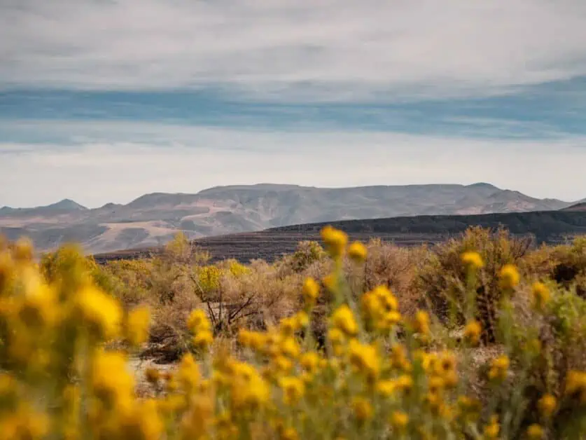
Within the section of Route 50 from Carson City to Austin, you’re going to experience some of the best the desert has to offer, you’ll get to enjoy sagebrush saloons, sand dunes, high mountains, native American art and so much more.
Setting Out from Carson City
Carson City signals the start of Nevada’s Route 50 and is easily reachable from places like Reno or Lake Tahoe too, so these could easily be added on at the start. However, it’s worth spending the night before you set out on The Loneliest Road in America in Carson City. It’s got some interesting areas to check out. It’s got a lot going for it from outdoors through to historic sites, art galleries, theatres, and museums. It’s also the state capitol! Even if you just spend a couple of hours looking around, you’ll see that there is a vibrant cultural scene in the city, with plenty to do to keep you interested.
Things to do in Carson City before Departure
Some of the main things that are worth checking out in Carson City before heading off on Route 50 are:
- Nevada State Museum
- Downtown Carson City
- Stewart Indian Cultural Center
- Carson Hot Springs
- Kings Canyon Waterfall
- Nevada State Railroad Museum
- Join a historic tour of the city, such as this one
Here are some of the options in more detail:
Nevada State Museum
The museum packs in a lot and is one of the most comprehensive museums in the American west. Combining several long-standing exhibits with specialist features, it is well worth checking out, even if just for an hour. Expect to see Native American focused perspectives and detailed accounts of alternate view points and histories. You’ll also expect to see exhibits that walk you through Nevada’s history as well as being able to take a tour of the locally famous underground mine. The museum gives a great perspective of the area and the wider Great Basin which you’ll spend the next few days driving through.
Nevada State Railroad Museum
If you’re into anything to do with locomotives, then be sure to check out this Carson City Museum, even if you just take 30 minutes to an hour to look around, as it’s full of rich cultural significance. Here you’ll get to check out iconic railcars such as The Glenbrook and The Inyo. It’s open from 9am – 4:30pm Thursday to Monday and costs $8 for adults and is free for children up to the age of 17.
Stewart Indian Cultural Center
Just a couple of miles outside of Carson City is Stewart Indian School and Cultural Center. It was originally a boarding school for Native American children and was in use from 1890 to 1980. Now, the museum is incredibly important as it brings light to the saddening attempts to dilute and remove the native culture from America by removing children from their families and away from their cultural heritage. They were forbidden from speaking their native languages and were made to adopt a western approach which was at complete odds from their culture.
As you visit the grounds, you can hear stories told by former students and it really is a humbling eye opener to some of the horrific treatment that was put upon the native Americans residing in areas reaching from Nevada, Arizona, California, and New Mexico. Admission is free, but the center relies on donations for preservation. Open from Monday to Friday 10am -5pm.
Skunk Harbor Hike
Difficulty: Easy to Moderate
Distance: 5.1km/3.16miles
Elevation: 194m/636ft. ascent and descent
When to do it: Best completed from April to mid-November
No stop in Carson City would be complete without a trip to Lake Tahoe – it’s incredibly iconic and not to mention stunningly beautiful, especially in the warmer months. This hike takes you down an old fire road, which is well graded and wide, to the Skunk Harbor shore. Keep in mind that this hike is downhill on the way down, so you will have this to climb back up at the end, but it’s well worth the effort and is never especially steep (except a few small sections). It’s a great area for paddleboarding or for taking a refreshing swim. You can also take a mountain bike on this trail too – so perfect for those with varied interests. You’ll start in forested areas before heading down to the lake shore where you’ll get a sense of seclusion from the bustle you might expect of Lake Tahoe.
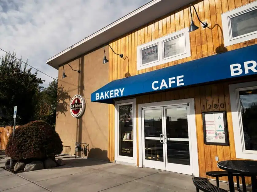
Breakfast at LA Bakery
LA Bakery was a great find on our visit to Carson City before starting Nevada’s Route 50. It had been voted as one of the best cafes in Carson City and it really did live up to the name. Baking fresh bagels and bread which taste incredible as well as cakes, and other savory, nourishing treats like wraps, sandwiches and more with specials frequently, this is a must stop place for breakfast. Their coffee is delicious too – their iced lattes are particularly good! The staff are also incredibly helpful in making changes to their menu – and whilst they don’t have anything on the menu specifically for vegans, they can amend to suit. There are numerous vegetarian options too, as well as gluten free options, so everyone in your group is likely to be happy. Everything is prepared fresh with quality ingredients to get your nourished for your journey. They’re located at 1280 North Curry Street, Carson City, Nevada.
Preparing for the Journey: Vehicle and Supplies
Whilst Life Magazine may have originally said that The Loneliest Road in America was only something to be attempted by the adventurous if you knew you could survive, we like to think otherwise. Really, this road trip just takes some forward planning and a bit of common sense. Like with any remote road trip, there are a few things you can do at the start to make sure you are prepared for the journey:
- Car/vehicle check: This is worthwhile doing before you leave but check that your vehicle is looking good for the journey. Make sure your tires are pumped to the optimum pressure and that you have a spare (and know to change it). Be sure the fuel tank is reading full (as fuel stops along the way on Highway 50 are limited) – but don’t worry, there are more than enough to make the trip work!
- Emergency supplies: Whilst it’s unlikely, it’s worth just being cautious. Bring extra food and water (we like to take extra gallon bottles of water in the trunk). Check you have a spare tire and that you know how to use. If you’re into adventure and have one already, bring a Garmin InReach, and let someone know where you’ll be.
- Food and drinks for the day trip: Be sure to bring more water than you need (it’s usually hot). We’d usually bring a gallon per person, per day to be on the safe side. Be sure to bring extra food and snacks too. If possible, bring a cool box you can keep in the trunk to keep everything in, and avoid perishable food as much as possible.
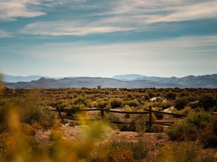
First Stop: Stillwater National Wildlife Refuge and Grimes Point
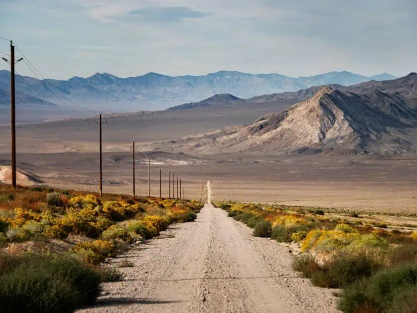
The first section of the Highway 50 route from Carson City to Stillwater National Wildlife Refuge will take you through the starts of the Great Basin as well as Fallon, well known for its Naval Air Station and where Top Gun is partially filmed. You’ll get used to hearing fighter jets flying over you at great speed very quickly!
The Drive
Generally, the journey from Carson City to Grimes Point and Stillwater Refuge takes between 1 hour 15 and 1 hour 30 to drive. This part of Route 50 starts to become wilder very quickly, though you’ll find the road conditions never stop being excellent. The scenery feels very open, and you’ll really start to get a feel for the vast expanse of desert you’re travelling through. On your way, there are also various points you can take in, such as Fort Churchill State Historic Park. It’s just outside of Silver Springs, about half way from Carson City to Fallon, and forms a key part of the colonial history of Nevada. It was built in 1860 and provided shelter for settlers and emigrants along the Pony Express.
Today, it’s just ruins, but you can take in the trails to see them. After that, you’ll go through Fallon which is a great place to stop for lunch. Depending on how long you’ve spent on your journey so far, it may be an early lunch, or you could get something to take with you to eat a little later. Fallon itself is well worth a quick look around, even if you’re a little short on time – there is a vibrant food scene that’s well worth checking out. We’d recommend The Slanted Porch, La Fiesta, The Courtyard Café & Bakery, The Wok and Maria Bonita as great places for lunch, all within easy walking distance of each other. Fallon is also another good place to stop for fuel if you didn’t do so at the start of the journey in Carson City.
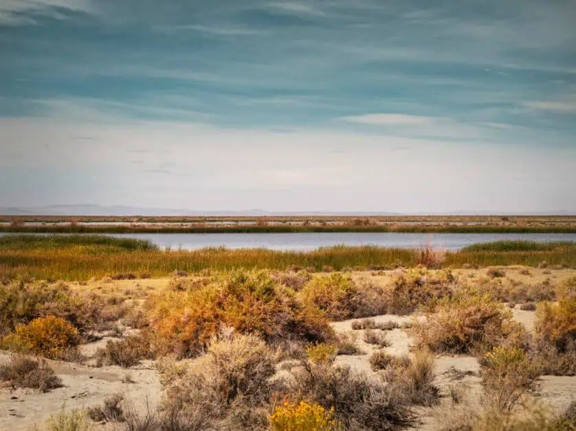
Stillwater National Wildlife Refuge
The refuge is well worth a visit along the way, and after Fallon, is the next stop along Route 50. It’s located in the Lahontan Valley and is a rich and incredibly ecologically diverse wetland habitat for over 250,000 million waterfowl. You’ll also find over 100,000 shorebirds and at least 20,000 other types of waterbirds. There is a lot to see and take in at this remote location, which feels peaceful and serene. However, the first thing you notice is just how much life you can see and hear around you. Considering the Stillwater National Wildlife Refuge is in the desert, it couldn’t feel further away! If you’re into birding this is a great spot, and even if the only thing you do is drive the Auto Tour Route, which takes under an hour, you’ll really get a sense of how precious and rich this habitat and oasis really is.
Historical Background
The Stillwater National Wildlife Refuge was established as a site of ecological and habitat importance in 1949 and was done so to provide a haven for migratory birds. Whilst its protection has only been in place for a short time, the Paiute tribe, local to the area, have been safeguarding and using resources at the marsh for thousands of years. It’s hard to imagine how Lake Lahonthan covered such a vast amount of the landscape almost 12,000 years ago. Of course, this was reduced massively in the end of the Ice Age but spend any amount of time looking at the mountains around and you’ll see evidence of the lake’s shoreline from time gone by.
Habitat Diversity
Within the reserve itself, there are various habitats to be found, and that can be explored either by driving the Auto Tour Route or by walking some of the short trails in the area. This itself makes the area very diverse and includes wetlands, marshes and uplands which support a vast array of species. The Stillwater National Wildlife Refuge has an incredibly rich, diverse, and unique ecosystem and its significance is well regarded around the world. In fact, it ranks as an area of international importance by the Western Hemisphere Shorebird Reserve Network.
Within the area, you’ll find a very expansive 79,570 acres of land that really punctuates itself in the desert that surrounds it. If you’re into wildlife spotting, there are plenty of opportunities – once you drive into the refuge, you’ll see many areas from which would be ideal to birdwatch. If you’re wanting to photograph some of the incredible species in the area – be sure to bring long lenses!
Stillwater Auto Tour Drive
Even if you do nothing else, be sure to drive the Auto Tour Route, which takes under an hour and is a self-guided gravel road that takes you around some of the most serene sights of the Stillwater Refuge. Once you enter the refuge coming from Fallon, the board at the entrance highlights the route, but it’s really easy to follow (and is marked along the way). In fact, if you’re a little short on time, this is one of the best ways to get a real feel for the rich diversity in the area. It’s a popular one to drive along, stop and take in the scenery and keep going, so take your time. It’s useable all year round too – and in winter, when there has been snow, the landscapes surrounding look particularly beautiful!
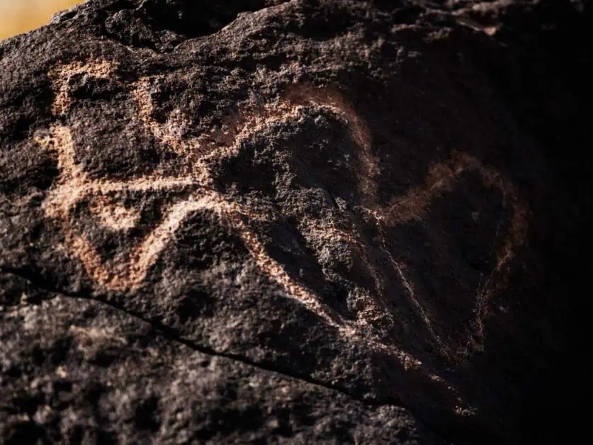
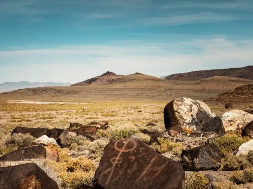
Grimes Point
The next stop, very close to the Stillwater Refuge is Grimes Point. Grimes Point is an incredible area of outstanding natural beauty. Not only does the area have unbelievable views of the surrounding high desert mountains, but it also allows you to get up close to artwork created by the native people of Nevada. Seeing these astoundingly well-preserved works is quite the experience. Below, you’ll find more information about what to expect from Grimes Point and why it’s worth checking out on your Route 50 road trip.
Historical Overview
Grimes Point is listed in the National Register of Historic Places, but what’s perhaps more important is its significance within native culture and art and the understanding of the areas early inhabitants. The native inhabitants set to carving pictures into boulders (otherwise known as petroglyphs). Over time (and we’re talking thousands of years here) the boulders started to become ‘desert varnished’ which happens when iron and manganese combine in desert, arid climates to leave polished reds and blacks. However, there is more to the area than art alone and subsequent archeological digs have found remnants of bone, shell, tools, and other items. This really is an area of unique importance, and a place to look far back in history.
Understanding Petroglyphs
Perhaps most importantly when checking out this area, it’s good to get an understanding of petroglyphs and the particular symbols and art found in the Grimes Point area. Essentially, they’re rock carvings that were made by pecking into rock surface with a stone chisel and hammer. When the surface is chipped off, the lighter surface underneath is exposed – over time, even when the rock weathers and ages, evidence of the artwork is usually still visible. At Grimes Point there are various shapes and animals to see. Such as sheep (bighorn) and swirls. Petroglyphs were often created before a hunt as a ritual by the group leader and if you look carefully, you’ll see some of these visual depictions close to the rest area where you’ll park.
Guided Tours
To increase understanding and enhance visitor understanding and appreciation of the site, there are now free public tours given of Hidden Cave Archeological Site by the BLM on the second and fourth Saturday of each month. The tour starts from Churchill County Museum in Fallon at 9:30am and is roughly 2.5 hours long. If this appeals, you’ll need to book this in advance.
Exploring on Your Own
If you prefer to explore on your own, or are short on time at Grimes Point, it’s really easy to explore on your own. There is a parking area with information on the area, and from that you can take the hiking trails listed below. Of course, it’s of the upmost importance to stick to the trail in order to preserve this rich historical area for years to come. You’ll want to bring your camera too, as there are some fantastic views of the high desert mountains all around, which really give you a sense of how big Lake Lahonthan was.
Petroglyph and Viewpoint Hike
Difficulty: Easy
Distance: 3.3km/2 miles
Elevation: 68m/223ft. ascent and descent
When to do it: All year, but avoid middle of the day in summer months
We’ve combined the petroglyph hike and viewpoint hike as one, but they can easily be split into two, making a much shorter hike if needed. We were seriously impressed by this hike as it packs in an awful lot for such a short period. You’ll get to be up close to some incredible works of native art on this hike, and the interpretive signs along the trail make for a really interesting way to experience and learn about the different types of symbols used and why. What’s more, the views out to the surrounding mountains are simply stunning, and especially so when you consider just the vast vistas you’re surrounded with. The hike along the petroglyph hike follows a linear trail with a small loop at one point, but you can extend to take you up to the viewpoint, which is well worth the extra effort. The Petroglyph trail itself is pretty accessible with no steep inclines or declines and is family suited.
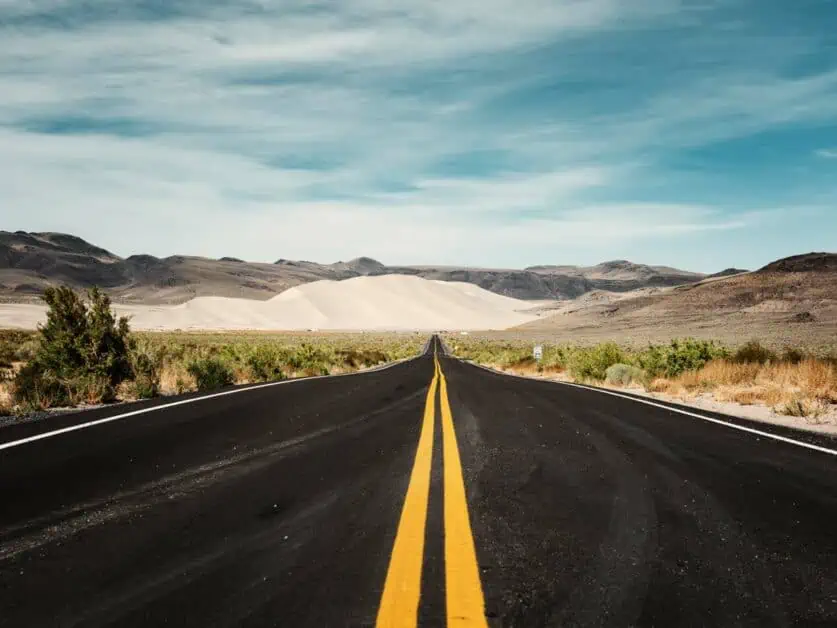
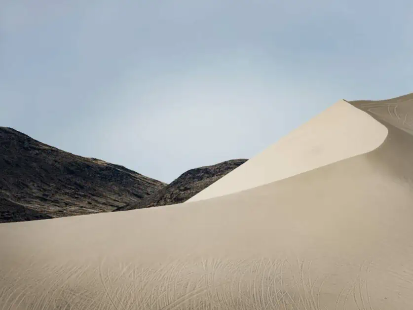
Journey to Sand Mountain
From Grimes Point, the next stop on day one of Route 50 through Nevada is Sand Mountain, which is a two mile long and 500-foot-tall sand dune, and a very impressive sight. This section of the desert is one of the most impressive on the whole journey and even though the time you’ll spend driving it is minimal, you’ll certainly remember it well.
The Drive
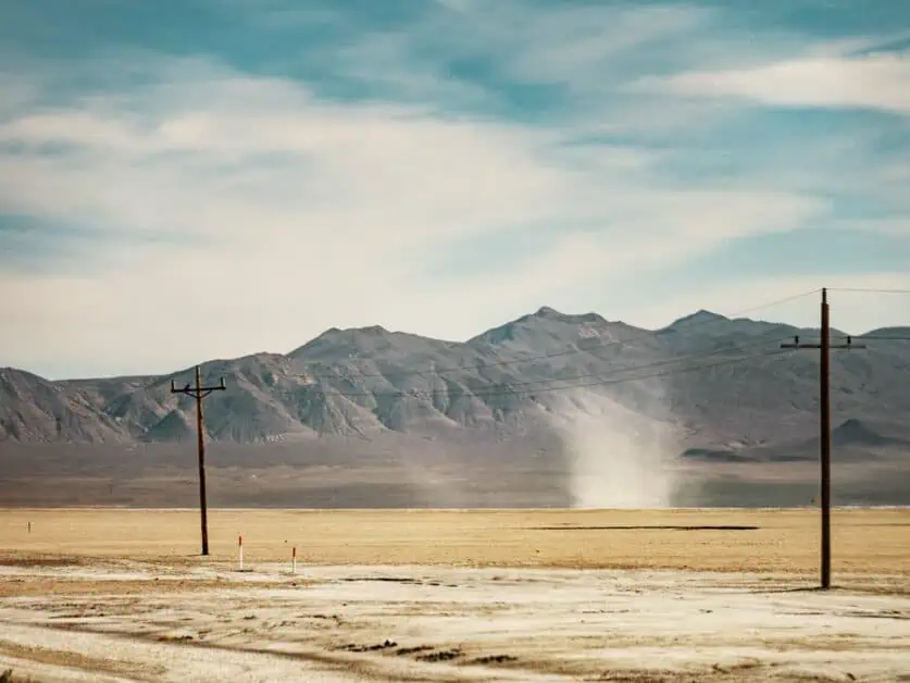
The drive itself is only 20 minutes so you won’t be in the car long at this point. However, the scenery along the way continues to get even more stunning – with the basin opening more and more. Be sure to keep a look out for dust devils along the journey as they make quite an impressive sight! There aren’t any important landmarks on route as such in this section, but it makes up for that with high desert mountain views. The road conditions are smooth and it’s pretty much a straight open road until you reach Sand Mountain to turn off, so enjoy the views and journey.
Sand Mountain
So, what is Sand Mountain? Sand Mountain Recreation Area is mostly a designated OHV fee site located 25 miles away from Fallon and just off Route 50. Sand Mountain is a pretty impressive sight – a 500-foot-tall sand dune which was created by windblown sand and stopped in place by the Stillwater Mountains around it. With this, it’s actually the largest sand dune in the whole of the Great Basin. What’s more, it really stands out in the landscape with its light color and interesting contours against the mountain backdrop. Even if you just pull up to take some photos of Sand Mountain before you head on to your next location, it’s well worth the stop to marvel at this natural masterpiece!
Historical Background
Sand Mountain has quite an iconic history too. In terms of Native American history, the dune is called Panitogogwa by the Stillwater Northern Paiutes’ people. This refers to the dune as a giant rattlesnake that is travelling with wind on its back. It’s said that you can hear the snake moving toward it’s hide or hole – which is associated with a phenomenon geologists refer to as ‘singing’ sand dunes. For early pioneers, the sand dunes were used as a landmark for Sand Springs, found nearby and which was a location for Sand Springs Pony Express Station in 1860.
Geographical Features
The prominent sand dunes are quite unique in this area. Ice Age Lake Lahontan, which dominated this whole area (and you’ll have seen from Grimes Point, your last stop) is responsible for Sand Mountain due to sands carried by wind. The mountains that sit behind are responsible for it staying in place, and this some 500-foot structure really is impressive to see. The Sand Mountain area is also home to the Sand Mountain blue butterfly, which can only be found here as it is dependent on local buckwheat plants – so if you see one of these striking insects, know it’s a rare treat.
Off-Highway Vehicle (OHV) Riding
Sand Mountain Recreation Area is one of the most popular sites for OHV riding in Nevada and you can take advantage of the 500-foot dune itself, or some of the smaller surrounding dunes too. Whilst it might be tough to stop and ride an OHV on route through Route 50, you can rent OHV’s from nearby cities – though this may be more of a whole day activity, so if this is something you’d like to do in more depth, it may be best to add extra time to your trip to factor it in. OHV riding really is a thrilling activity and allows you to get up close and personal with the landscape and enjoy it in a different way to what you might be used to already. As well as riding on the open dunes there are some 23 miles of trails established to enjoy and take in the surrounding landscapes.
Sand Mountain is a fee area, at present, it’s $40 for 1-7 days use or $90 for an annual pass. You’ll need to pay before you enter the site, and you can pay online here through recreation.gov. You’ll need to print out and download the pass on your mobile before you visit. The cell reception is limited so it’s worth doing this in advance. In order to have a safe experience, there are certain guidelines you’ll need to follow.
When you visit the site, you’ll see a number of rules set out and listed near where the fee area comes into effect. You’ll need to stick to enforced speed limited to avoid any accidents and be careful when reaching the top of dunes and proceed cautiously as winds can create ‘slip faces’ and ‘razorbacks’ on the dunes (a steep drop off). You’ll also need a fluorescent orange ‘whip flag’ which extends at least 8 feet above ground level when the vehicle is at a stop and is mandatory on all OHV. There are also some primitive campsites available on site, too. There are also opportunities for sand boarding and sand sledding if that’s more your thing!
Photography & Sightseeing
Whilst there aren’t really any hiking trails around the dunes as such, OHV riding does give some of the best views of the landscape in the area. So, if you’re lucky enough to spend some time riding the dunes at Sand Mountain, you’re likely to get some stunning shots looking across the dunes and into the nearby mountains. Some key tips for photography enthusiasts would be to stake this area out toward the end of the day toward sunset, as the dunes start to really light up and twinkle in the lowering sun.
Being atop of the dunes really are some of the best spots for capturing stunning views and landscapes. However, even if you pull up just outside of the fee area to marvel at the dunes, you can still get some fantastic shots. If you have longer lenses for your camera, you can really zoom in and get some great abstract shots, using the shapes around to define things. You can also get some beautiful shots of the dunes against the surrounding landscape and road easily too – this area really stands out as a great place for photography!
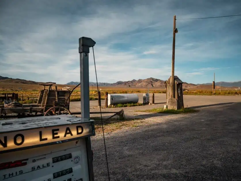
Middlegate Restaurant and Gas Station
Middlegate Restaurant and Gas Station is one of the last stops of the day for day one of Route 50 driving through Nevada and it really is an iconic one that will hopefully stay with you a long time. A traditional sagebrush saloon sitting in what feels like the middle of nowhere just off The Loneliest Road in America, Middlegate Station really does have a wild west ambiance. It was established in 1860 as a Pony Express station and has some of the most scenic views alongside authentic charm you could hope to experience. It was short lived as an express route and was then turned into a stage and freight station until the early 1900s.
Now that’s all in the past, it was restored by the BLM and it has some of the most friendly people you could hope to meet working there and has a homely burger restaurant as well as a fuel stop (which is quite the experience and a great place to top up as it’s the only gas station for near 50 miles in either direction). Even if you just stop in for a quick drink and fuel top up, you won’t want to miss this stop for the interiors and exteriors and the photo opportunities.
The Drive
The Drive between Sand Mountain and Middlegate Station isn’t a long one – about 24 minutes and 23 miles, but you’ll be continuing to see some of the most stunning landscapes along the way in the high desert. If you fancy it, there is a turn off to go and see a fault line along the way. You’ll see a sign notifying you on the right and you can turn off onto the dirt road to go see it. It does take some driving up the dirt road to get there, and the actual fault line itself isn’t hugely visible, but the landscape views from that higher perspective are stunning and well worth a look. Along the way from Sand Mountain to Middlegate, you’ll likely want to stop along the road to take in the Desert Marigolds which are likely out in a plenty and make a great framing for some wonderful desert photographs.
Food and Drink
At Middlegate Station, you’ll find everything you would expect from a typical bar, but with the exception of an impressive burger menu. In fact, Middlegate Station is well known for its burgers and hearty meals at really reasonable prices. If you’re looking for a great entertainment option before you head to your lodgings for the night, Middlegate Station is a great choice. The staff are friendly and will have you feeling right at home and welcomed. Middlegate Station actually has a pretty extensive burger menu, even including vegetarian and vegan burgers (at the time of publishing, they were using the Impossible Burger) and were well versed in meeting any dietary requirements. One of the must try dishes is the Middlegate Monster Burger that certainly wouldn’t leave you with any room afterwards and is classed as a ‘food challenge’ and often seen on bucket lists as something to tackle!
Final Stop of the Day: Austin
Austin, Nevada is classed as a ‘living ghost town’ and it will be the last stop of your journey for the first day of Route 50. Whilst technically classed a city, this small unincorporated community was originally occupied by the Western Shoshone people. Now, it’s a small area with a couple of food places and lodging, mostly in place for people driving The Loneliest Road in America. It’s well worth spending a little bit of time looking around as Austin, Nevada is well preserved and a great example of an early Nevada mining town.
Places to Stay in Austin, Nevada
With Austin being such a small place, there aren’t that many places to stay and really, they mostly serve people passing through or people completing Route 50 through Nevada. Because of the limited places to stay, it is advisable to book your accommodation in advance to make sure you have somewhere to stay as there are no traditional style motels like you may expect in other areas where you can just turn up and get a room for the night. This is something you’ll find as key for all of Route 50- be sure to book that side of things in advance, with that bit of planning, you will ensure as smooth a journey as possible, meaning you can enjoy the trip more than anything else.
Cold Springs Station Resort
If you want a place to stay that is actually between Middlegate Station and Austin, Cold Springs Station Resort is a great place. The rooms are basic, so don’t expect the lap of luxury, but this is all part of the charm on this part of Highway 50 and just adds to the ambience. The resort has a small selection of hotel/motel/cabins and RV park that can be reserved. The resort also has a restaurant and bar serving breakfast, lunch and dinner as well as a gift shop and various other amenities. It really is the closest thing to being right in the thick of it with nature and it’s peaceful setting makes for a great restful stop.
Hotels in Austin, Nevada
Accommodation options in Austin, Nevada are limited, but here are the best hotels, lodges, B&B’s and vacation rental options for your stay:
- Cozy Mountain Motel: 40 Main Street, Austin, NV 89310, +1 775-346-1566
- Union Street Lodging: (Bed and Breakfast), 69 Union Street, Austin, NV 89310, +1 775-964-2364
- Paradise Ranch Castle: GPS: 39°26’01.1″N 117°16’18.8″W, +1 440-781-9768
Where to Eat in Austin, Nevada
Due to Austin being a small place, there aren’t that many options for food and drink in the area, so it’s always best to plan ahead and check local opening times to make sure to avoid disappointment. Here are some of the best options for where to eat in Austin, Nevada:
- International Café & Bar: 59 Main St, Austin, NV 89310. Serving a range of hot and cold sandwiches, soups and sweet treats.
- Grandma’s: 99 Main St, Austin, NV 89310. Serving steaks, traditional American fair with mashed potato and gravy, such as chicken dinners, desserts, cocktails and beer.
- Austin Owl Club: 89 Main St, Austin, NV 89310. Serving pizzas, wings, corn dogs and Philly cheesesteaks. With pool tables and an old-time bar feel.
Conclusion
Day one of Route 50 is in some ways the most full on, or involved, and there are some real highlights on this day. You really start to get a sense of the open road and a true feel for the desert. Some of the highlights are certainly Middlegate Station, but we were amazed by just how much there was to do and see around Stillwater Refuge and Grimes Point. We could easily have spent a lot more time there, and we actually wished we’d had an extra day here. If you can afford the time, we’d recommend allowing some more time to check out all of the areas in and around Carson City, and more time at Stillwater. If time is of the essence, you could very easily leave out Sand Mountain or just take a few photos and take in the sand dunes as you drive past (they are very visible from Route 50 itself). Day one really is an incredible day, with so much to see and learn about in the landscape!