Best Tarn Hows Walk, Lake District: Easy to Follow Guide + Downloadable Maps
Tarn Hows is by far one of the most stunning tarns in the Lake District. It’s manmade, but don’t let that fool you – with breath taking views of the iconic Langdales and surrounding mountains in the background and the mysterious dark, sometimes mirror-like water hugged by trees – this walk is a must do.
It’s fairly short, and the Tarn Hows walk itself is relatively accessible, with undulating but never steep inclines over well graded paths. It is even possible to rent Trampers from the National Trust office at the main car park, making this a walk for most if not all.
There are also plenty of options from the Tarn Hows walk itself to head off to other crags and fells – the main one being Black Crag or Fell which, if added to the Tarn Hows walk allows you to get in a Wainwright – and is classed as one of the easier Wainwrights.
The area itself has quite a bit of history surrounding it – the tarn itself was created in Victorian times, so it is man-made. It was once three smaller pools which in the 1800’s was dammed and turned into the one tarn you’ll experience today. It is now owned by the National Trust and was sold by Beatrix Potter.
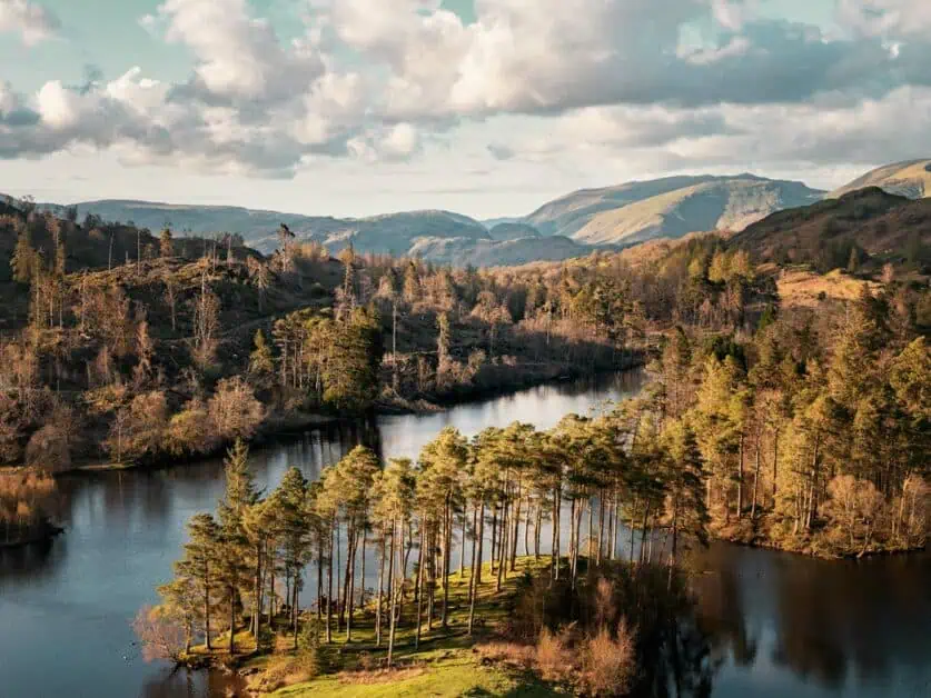
Tarn Hows as seen from upper viewpoint
Tarn Hows Walk
AllTrails map alternative: The AllTrails Map available adds a section for a different starting point, but you can just follow the loop around the lake only and still park in the same National Trust car park. Difficulty: Easy/for most. Some slight gradients and undulating terrain, but never steep and extremely well graded/surfaced throughout. Suitable for pushchairs and strollers. Trampers can be rented from the National Trust and can be picked up from the main car park kiosk. You’ll need to pre-book one using the National Trust information page here. Distance: 3km/1.86miles Elevation: 23m/75 ft. ascent and descent When to do it: Accessible all year round (except for after heavy snowfall, the road to reach the car park may not be accessible).
About our walking maps: We use Outdooractive to provide real time views of our walks. You can download the route or print it out by clicking on the map which will open directly in Outdooractive. They offer a free plan which allows you to save offline maps. You should always download your route first to prevent problems when loss of signal occurs on the trail.
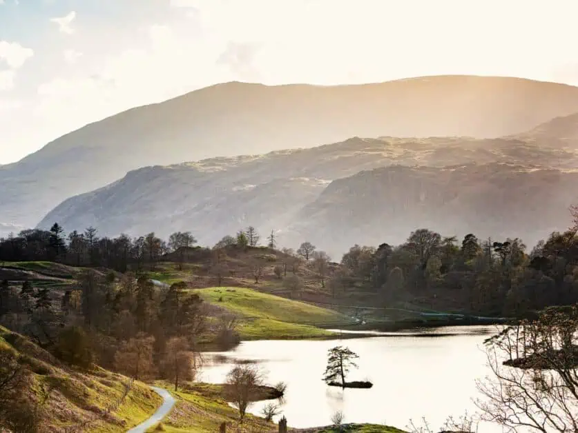
Tarn Hows from Upper Viewpoint on return trail
Walking Route Description
Once you’ve parked up in the National Trust car park for Tarn Hows, follow the sign out of the car park for the tarn. You’ll cross the road that you drove in on, down a graded path. You’ll soon see the fantastic view of the tarn with the mountains in the background. It’s absolutely breath taking!
At this point, yield to the left and go through the gate – at this point you can start following the path around the tarn.
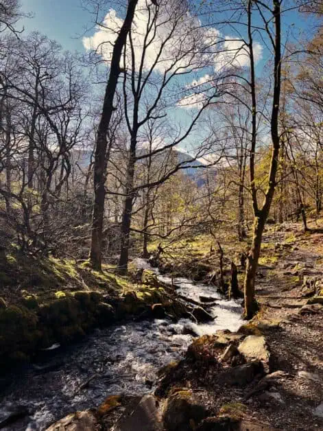
Shortly after entering the main trail from the gate, you’ll see a sign to the left for waterfalls – this is for Tom Gill waterfall. It’s a short detour (a few hundred metres there and back and is well worth the extra effort. Take care when it’s been raining as the rocky path can be slippery underfoot.
As you walk around, you’ll see a number of tree stumps with coins in them, and if you go at the right time, you may also see frogs in the stream beds that feed the tarn.
Keep walking around on the well graded path and you’ll keep turning right as it follows the shore of the tarn.
At the top of the lake, there is the option to turn off and continue straight on to reach Black Crag (which we give directions for later on in this article). If doing the Tarn Hows circular alone, keep bearing right along the well graded path.
You’ll come to a gate at the very top of the lake, go through it and keep bearing right.
At this stage, you will be on the other side of the lake, keep following this straight on all the way back to the car park. If you want a truly spectacular view of Tarn Hows from higher up, at about 3/4 of the way around the lake and shortly before the path joins the main road, you’ll come to a sign on the left with a gate for a viewpoint and also for Rose Castle Cottage. It’s well worth taking this upper path back (which joins the road just a little further on from the main path. As the views you get from this viewpoint are stunning.
Depending on which path you took, you can either exit a little further up the road and walk back or head back down on the main path and exit via the gate you entered the tarn walk from.
Tom Gill Waterfall
Useful Information About the Tarn Hows Circular Walk
How to Get There
Car: The postcode for Tarn Hows is roughly LA22 0PP. If you type National Trust – Tarn Hows park into your sat nav, then you should have no trouble finding it. Do keep in mind there isn’t much phone reception around there. The walk is about a 10 minute drive from Coniston via the B5285 or about 16 minute’s drive from Ambleside via the B5286. In both directions, you will see signs for Tarn Hows.
Bus: It isn’t well served with buses and there is no direct way to reach Tarn Hows via public transport. The closest bus stop is at Hawkshead Hill which adds about 1.5km to the start (and end) of the walk, and is up and down hill, so keep that in mind. You can catch the 505 bus between Ambleside and Coniston.
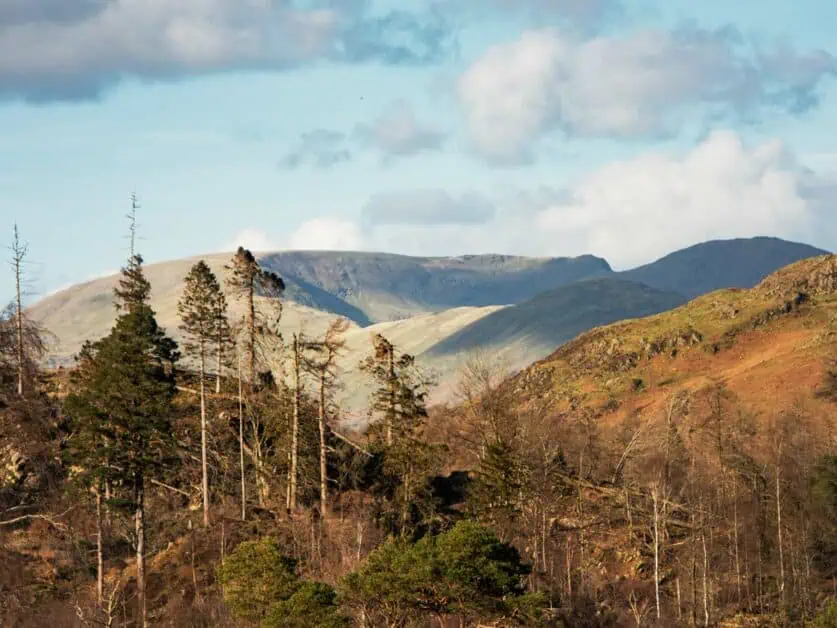
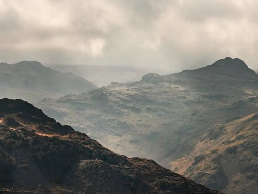
Views surrounding the top end of Tarn Hows
Parking
There is a relatively large car park at the bottom end of the lake from the road – this is a National Trust car park, so there is a fee to park. You can pay contactless or by card. Contact the National Trust for up to date information and pricing. This is free to National Trust members. It does fill up quickly on busier periods and holidays, so keep this in mind when planning your visit. The postcode is LA22 0PP or use ‘National Trust – Tarn Hows’ on your sat nav.
Accessibility
The Tarn Hows walk is relatively accessible to all – meaning it has no steep inclines and the path is well graded the whole way round. It is suitable for strollers and push chairs too, as well as wheelchair users. It is also possible to rent a tramper for your time at Tarn Hows – this can be done in advance via the National Trust and it can be collected during their kiosk opening hours in the main car park (you can collect between 9:30am and 1:30pm). A tramper can be reserved for 1.5 hours at a time. At present, they are free to use and you do not need to be registered as disabled or have a Blue Badge to be able to reserve one. You can find out how to reserve one through their website here.
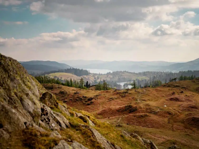
Views from the upper path of Tarn Hows
Facilities
There are toilets available at the Tarn Hows National Trust car park which are free to use. The car park is also open 24 hours a day but it is not allowed for overnight stays or campers. Dogs are also welcome on the trail.
Optional Black Crag Wainwright Walk From Tarn Hows
A great option to extend the Tarn Hows walk is to add on the route up to Black Crag or Black Fell as it’s also sometimes named. Whether you’re new to the Lake District or not, Black Crag is quite significant as it is noted as one of the easier Wainwright’s in the National Park. This walk offers some truly stunning views of the surrounding mountains and it’s elevated view point also offers wonderful views back over Tarn Hows from the summit. It is well worth doing!
View from Black Crag and Tarn Hows walk
Black Crag from Tarn Hows Walking Route
AllTrails map alternative: Black Crag and Tarn Hows Difficulty: Easy to moderate – easy around the tarn with well graded paths all around. Up to Black Crag, some steeper sections, with loose, uneven terrain. Distance: 6.2km/3.72miles Elevation: 143m/469ft. ascent and descent When to do it: Trail should be accessible all year round except after heavy snowfall, the path to Black Crag may be inaccessible and the road to reach the car park may also be inaccessible.
Route Description
Meeting up at point 5 on the Tarn Hows Walk listed above, rather than following the top of the tarn round to the left, keep going straight on along the Cumbria way. Many people take a slightly different route, but we prefer this option as we feel the views that you gain on this slight detour are well worth it (and don’t add any extra incline or distance either).
After you’ve followed the Cumbria way, you’ll come to a gate, go through and take a right up the gravelly hill. The views of the Langdales become breath taking as you get higher and higher on the trail.
At the top of the hill, you’ll take a left through the beautiful Iron Keld Plantation – a forested section which takes you most of the way up to the final push before the Black Crag summit. You may even see some cows (generally Belted Galloway’s) on this section – they’re gentle giants but treat them with caution and calmness as you pass them.
When you come out from the woodland, take a right up the hill – this is the last section up to the top of Black Fell. If you want a little detour, keep walking straight on for a few hundred metres until you reach the rocks – you’ll have fabulous views over the mountains and it’s a nice quiet spot for a break, or even lunch on the route. You just need to backtrack to the turn off to complete Black Crag.
When taking the right up the hill, the path does become a little indistinct in places, but there are numerous little paths that head up to the top.
The last section needs you to walk up a small steep section to reach the cairn.
Retrace your steps back down the way you came and continue the Tarn Hows walk listed above from point 5.
Tarn hows seen from Black Crag
Tarn Hows and Black Crag video guide
Use our video guide to get a feel for what you’ll see on the Black Crag walk from Tarn Hows:
There is sadly no free parking in or around Tarn Hows. The car park at Tarn Hows itself is National Trust and requires a fee to park. As do the other car parks in the area, wherever you walk in from. It is important to remember that whilst there may be various small laybys on the way, these are passing places and are intended for cars to use to get past each other along the narrow roads. These roads are used by emergency vehicles too and blocking them can prevent access where there are no other roads to get to them.
Surrounding mountain views at Tarn Hows
Can you walk from Coniston to Tarn Hows?
It is possible to walk to Tarn Hows from Coniston. It does make the route longer and does include more incline, but it makes a great way to see more of the Lake District. There are also several main car parks in Coniston which can, if you’re up for it, offer an alternative to the National Trust car park at the tarn when it’s full. We’ve included an alternative Tarn Hows walk route below from Coniston which you can download. Once you’ve completed a loop of the tarn, you can either retrace your steps back down to Coniston or take our slight different return for varying views.
How do you get from Ambleside to Tarn Hows?
You can easily reach the Tarn Hows walk from Ambleside via several options. To drive, it’s about 16 minute’s from Ambleside and you’ll take the B5286. Once you’re closer, the road to the tarn is signposted. To get the bus, you’ll need to take the 505 toward Coniston. It doesn’t stop at Tarn Hows itself, but you can get off at Hawkshead Hill. It is roughly 1.5km extra walk (there and back) with some up and downhill – so keep that in mind.
Can you swim at Tarn Hows?
Whilst swimming at Tarn Hows may look tempting, swimming isn’t currently allowed in the tarn. The tarn is of scientific interest, and as such this important habitat is protected from all water sports. If you fancy a swim, nearby Coniston Water is a great alternative. From Monk Coniston car park, there is easy lake access. For other swimming spots and inspiration, be sure to read our guide: 22 Best Places for Wild Swimming.