
Until 2020, The South Downs National Park had been somewhat of a training ground for us. Being within close proximity to our house in London, we’d often find ourselves heading out on hikes there to test out new gear or get ready for particular trips. That, however, says more about how our mindset was before lockdowns and Coronavirus. We hadn’t really seen just what we had on our doorstep until this point. We remember, when we came back from an extended period in LA in 2019, the first hike we took out in the South Downs felt really incredible. We marvelled at the rolling, green hills after so long spent in the desert and saw it in a new way, but that didn’t last too long as soon as we headed off on our next project.
Returning to the South Downs
Of course, for quite a long time through the lockdowns we experienced in the UK, we stuck close to home, but as restrictions were lifted, we slowly started heading back out into the hills of the South Downs. Recently, we went on a short weekend break and really fell back in love with the area – it presented us something we’d kind of forgotten. Or perhaps needed to re-see with fresh eyes and a developed perspective. If you’re in search of challenging hills, then this is the place. If you’re in search of coastal views, then this is the place. If you’re in search of forests, woods, lowlands and everything in-between, then this is the place. The South Downs presents an opportunity for serious hill walking and as well as the routes we’ve suggested below, it is possible to create your own routes with the plentiful paths that any amount of time looking at a map of the area will inspire you to follow. Within the National Park is also the South Downs Way – a long distance hiking route which can be completed over a number of days and is actually something we’re in the process of looking at for one of our next adventures. The trail is 161km in length and begins in Winchester and ends on the dramatic cliffs of Eastbourne. The thing that makes this route great is the fact that it’s possible to cut down off the hill and head into any number of the small towns along the way to stay in. There are many areas of this trail accessible by train meaning it’s possible to even do it over a number of weekends if hiking for seven to nine days straight isn’t a possibility for you.
The great thing as well about the South Downs is its proximity to many big cities and towns – London is within a roughly 1hr40min drive with a number of train services from central London stations to smaller starting point villages with easy access to trails. You’re also close to Brighton and Eastbourne which makes it incredibly accessible. If you’re coming from further afield, the South Downs is situated right next to Gatwick airport and is also just off the motorway and a straightforward drive from many other areas within the UK.

Image description: A landscape image. Fay is walking into a winter landscape – with a light haze coming in top left of the frame. Fay is walking away from the camera and is wearing a thick, purple coat, hat and large backpack.
The South Downs are the newest of the National Parks in the UK – celebrating only its tenth year with this status in 2020. The South Downs are absolutely wrapped in history, and when you look at a map, you’ll see a whole host of earthworks and other wonders. If this isn’t really your thing, we get it, but it’s also kind of amazing to think just what has happened on the land you’re hiking on, if nothing else.Some sites date back over 5,000 years!
You’re also offered something pretty incredible in the South Downs – solitude. Sure, you won’t have every path to yourself, but in general, the place is big enough that you’ll be able to keep your distance from others where needed, but also have a great place to think and reconnect. We can probably count on one hand the number of people we’ll see in our time in the South Downs – apart from around Beachy Head which is a very popular spot and a much higher footfall.
So, with much love and consideration, we’ve put together below our downloadable GPX routes of our current favorite hikes in the South Downs National Park. These hikes are from a long list of hikes we’ve enjoyed over the years here, and have been selected because of their views, their difficulty and also what they offer. As always, if you try any of the hikes below, please tag us!
Please find all up to date safety information relating to Covid-19 and the local community before heading off on your visit to The South Downs. For more information, we encourage you to please head to theSouth Downs National Park Authority Website.
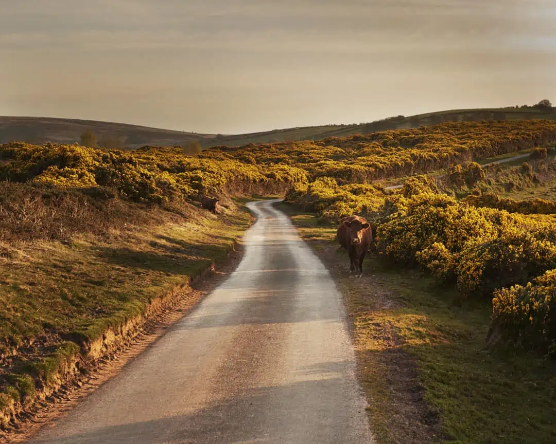
Image description: A landscape image. It is golden hour and everything in shot is painted with gold, orange and low level light. There is a cow walking down the road in the foreground on the right hand side, and you can see into the distance on this country road. You can see rolling hills in the background.
Chanctonbury Ring and South Downs Way – Shorter Circular
Length: Roughly 9km
Ascent: 248m
Descent: 248m
What you’ll see and experience: Incredible rolling hills, hilltop walk, the sea, woodland, earthworks, diverse and changing landscape, quiet, peaceful experience.
Chanctonbury Ring and South Downs Way – Longer Circular
Length: Roughly 15km
Ascent: 424m
Descent: 424m
What you’ll see and experience: A more challenging route because of distance and height gain, with extended rolling hills, hilltop walk, the sea, woodland, earthworks, diverse and changing landscape, quiet, peaceful experience – you’ll know you’ve hiked this by the end of the day!
Harrow Hill via Storrington – Linear hike
Length: Roughly 9km one way
Ascent:247m one way
Descent: 103m one way
What you’ll see and experience: A beautiful hike through rolling hills and forests which culminates on fantastic views at the top of Harrow Hill. This hike could also be started and finished in Storrington for a shorter route. The panoramic views of the landscape from the top of the hill are fantastic, but the views you experience the whole way are part and parcel of a beautiful hike.
West Sussex and Parham Wood Circular
Length: Roughly 10km
Ascent:100m
Descent: 100m
This hike is a really lovely one if you only have a couple of hours to spare – you start to experience to views of the rolling landscape of the South Downs amidst really interesting woodland. We’ve found this hike incredibly peaceful, relaxing and rejuvenating every time we’ve done it.
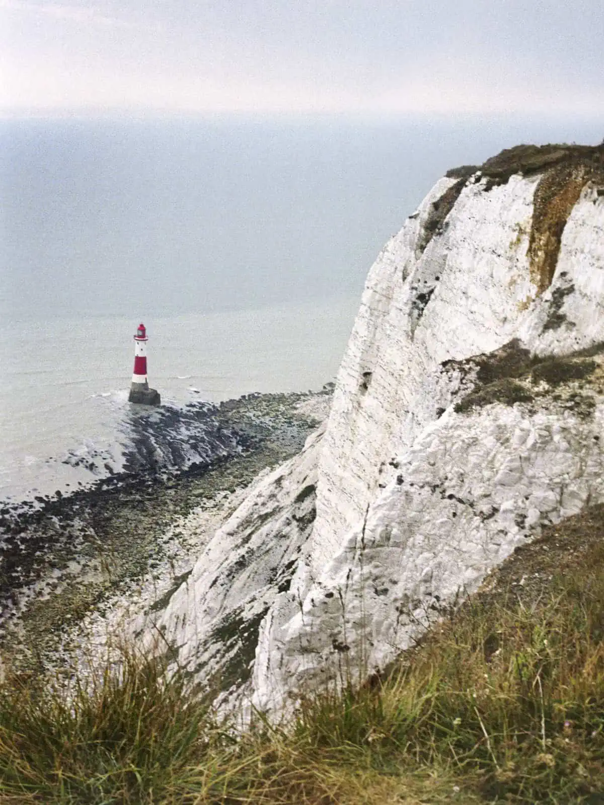
Image description: A portrait image. The white chalky cliff frames the right hand side of the image, and leads the eye down to the blue of the sea at the top left corner of the image. In the sea is a white and red striped lighthouse.
Seven Sisters Cliffs and Friston Forest
Length: Roughly 13.5km
Ascent:413m
Descent: 412m
When you look up The South Downs or ‘hikes near London’ on Google, one of the first things that will come up is a picture of the iconic white cliffs that frame Eastbourne – named Beachy Head. The Beachy Head route itself is extremely popular and offers an up down up down cliff experience which is enough to get you knowing you’re alive and out for a hike! This version actually takes you slightly away from the main pull, still taking you over beautiful cliff top views but taking in wonderful forest and slightly inland hills on the other side. On a sunny day, the sea looks turquoise and you could almost not believe you’re in England but be careful – there is little to no shade on the coastal side of this hike. Combined with hills, this can get quite energetic, so on sunny days, be sure to bring a hat if possible and some sun protection as well as lots of water. This is absolutely a day hike and one you’ll most likely know you’ve done by the end!
Kingston near Lewes Circular
Length: Roughly 18km
Ascent:452m
Descent: 452m
A lovely, long hike taking in many of the hills near Lewes with views of chalky hill walls and rolling, stretching out for days views of the landscape.
Glynde and Lewes Circular
Length: Roughly 10km
Ascent:345m
Descent: 345m
Very close in location to the Kingston near Lewes hike, but with different views but just as beautfiful. Expect rolling hills and some steep ups and downs.
Alfriston and River Cuckmere Circular
Length: Roughly 13km
Ascent:265m
Descent: 264m
This was one of the very first hikes we did in the South Downs and it is one we keep coming back to. Gorgeous, hillside views, expanses so wide you can get lost in, peace, quiet and just incredible beauty.
East Meon Circular
Length: Roughly 14km
Ascent:286m
Descent: 286m
This is one of our absolute favorites in the South Downs. Expect the gorgeous sounds of the river, you’ll likely see people out gliding if conditions are right, many rolling hills, woodland and everything inbetween. A perfect hike to get lost in and reconnect with yourself and nature.
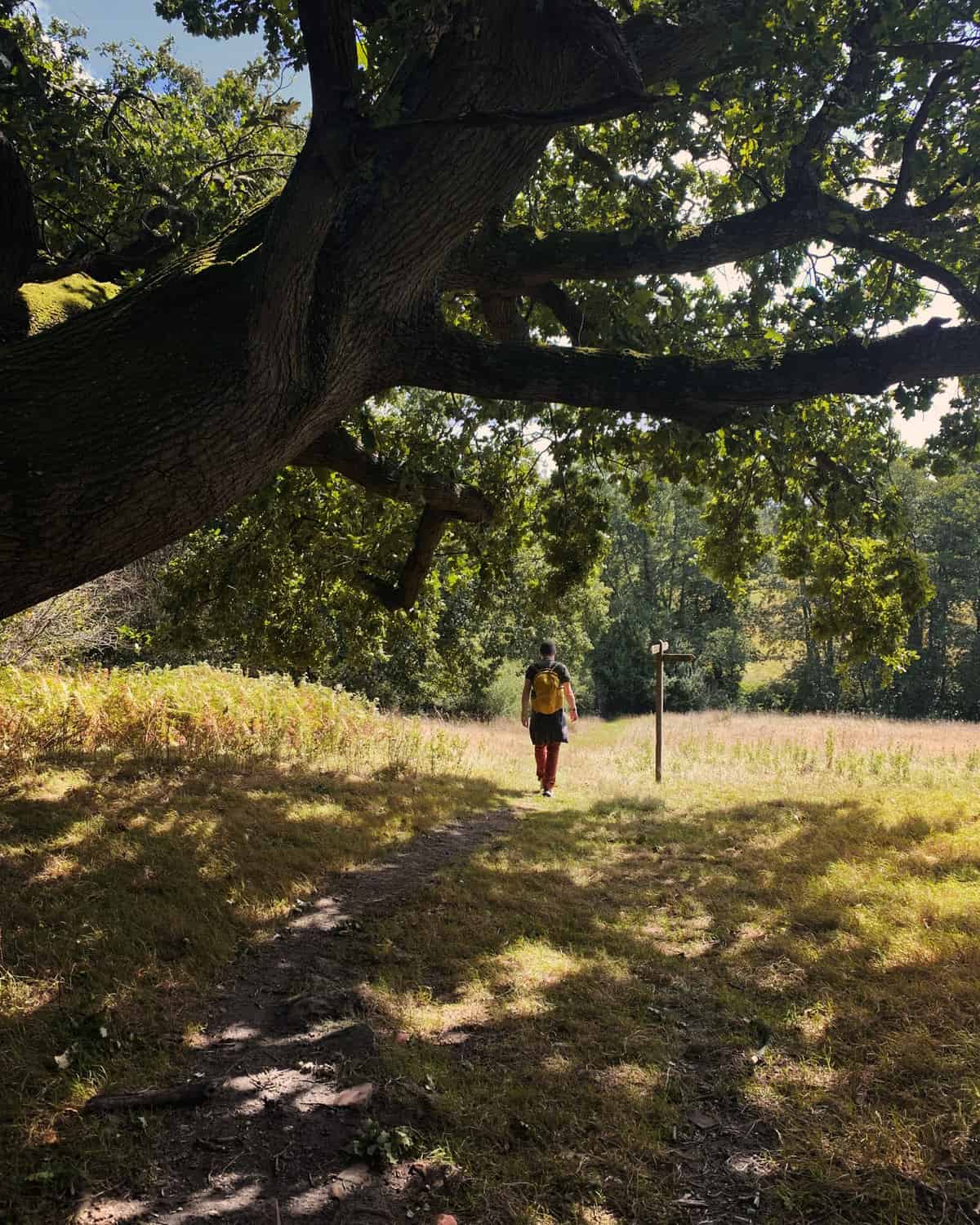
Image description: Matt is walking small and centre in frame of this portrait image. A tree is framed in the top left of this image coming into the shot and frames the composition of the image and creates a mottled light on the grassy woodland he is walking through. It is a summers day and he is wearing a t-shirt and small backpack that is yellow in colour.